
Showers and thunderstorms over the next day or so are expected to give way to sun by Christmas, as the National Weather Center warned of possible hailstorms Tuesday morning.
Newton County was struck by heavy rains overnight, with a severe thunderstorm warning in effect until midmorning.
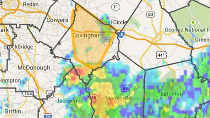
The storm was moving from Monticello towards Porterdale, Covington. According to the National Weather Service in Peachtree City, at 9:56 the service dopplar radar indicated severe thunderstorms capable of producing quarter sized hail. This story was located near Covington and Porterdale and moving northeast at 40 mph.
The warning also covered Conyers, Social Circle, Oxford, Porterdale, Georgia International Horse Park, Starrsville, Gun Creek, Brick Store, Almona and Rocky Plains.
The public was urged to remain indoors, preferably in a strong building away from windows, and report wind damage, hail or flooding to the National Weather Service at 1-966-763-4466 or tweet it to @nwsatlanta.
The service describe the storm as "dangerous" and warned the public to prepare immediately for large, deatructive hail capable of producing significant damage.
By 11, the storm appeared to have passed uneventfully. The National Weather Service predicted rain throughout the day with patchy fog in the afternoon, East winds of 10 to 15 mph, and temperatures in the mid 50s. More rain and possible thunderstorms are expected Tuesday night
Wednesday will also mostly likely see showers with a chance of thunderstorms, and highs in the upper 60s with a 30 percent chance of rain in the evening and lows around 40. The weather should remain clear until Saturday, when the center predicted a 40 percent chance of showers.