
Some members of two county-level boards still had questions about proposed changes to districts they represent after the state’s reapportionment office released maps drawn in response to population growth found in the 2020 federal census.
The Newton County Board of Commissioners and the Newton County Board of Education recently met for a joint work session to see changes to the five districts represented by members of both boards.
The Georgia General Assembly’s Legislative and Congressional Reapportionment Office created the maps that suggested changes down to the street level that equalize populations in all five districts, officials said.
The geographic areas of each of the five school board districts correspond to the same numbered districts of the Board of Commissioners. A school board member representing District 1 represents the same residents as the Board of Commissioners’ member representing District 1.
County Geographic Information System (GIS) Director Tim Lawrence and other county officials presented the recommended changes the Reapportionment Office made based on population increases in Newton County between 2010 and 2020.
County Attorney Patrick Jaugstetter said the state Reapportionment Office drew the lines for all 159 counties based on principles that generally can pass legal challenges.
He said the redistricting process began with drawing districts that each roughly contain an equal number of residents — in accordance with the Equal Protection Clause of the 14th Amendment that requires legislative districts in all states be equal in population.
Lawrence noted Newton County had 99,958 residents when redistricting was last done after the last federal census in 2010.
Because of the requirement for equal population between the five districts, each district was determined in 2010 to have an “ideal” population of about 20,000, he said.
The districts were drawn to include almost 20,000 in each district, with a more densely populated district being smaller in size than a district in which the population is more spread out.
By the 2020 census, Newton County had increased in population by 12.5% to 112,483 residents. Because of that total, each of the five districts now ideally contain 22,497 residents.
District 3 in northwest Newton bordering Rockdale and Walton counties now contains 24,401 residents and increased in population by 1,904 above the 2020 “ideal” population.
District 5 in northeast and central Newton was the only other county that exceeded the ideal number and was only 106 residents above it.
As a result, the Reapportionment Office removed more residents from District 3 than any other to equalize the district populations, including subdivisions moved into either District 2 or 4 such as Salem Village and Brookstone.
District 3 School Board member Shakila Henderson-Baker noted new subdivisions are planned for construction in her district that could significantly increase the population within the proposed district lines in the next decade.
“Once you do the reapportionment then District 3 is back where it originally was with it being the largest district again,” she said.
Jaugstetter said the Reapportionment Office’s changes do not account for expected future growth. He also noted construction plans do not always come to fruition — as witnessed during the Great Recession of 2008 to 2012.
Baker said she also needed to see the same numbers for both 2010 and 2020 to make sure the process was being done fairly. Board members only saw 2020 population numbers broken down by race and residents above age 18.
Jaugstetter told the elected officials they can make changes to the recommended district map but anything differing from what the Reapportionment Office sent must be returned to the same office for approval and recertification.
A member of the Georgia General Assembly must sponsor the county’s redistricting plan — with or without any local changes — and the full General Assembly must approve it, he said.
District 3 County Commissioner Alana Sanders said she did not want to comment on the proposed changes because they are not final.
“Many still have questions and this was the first meeting of the minds,” she said.
“TRADITIONAL DISTRICTING PRINCIPLES”
According to the National Conference of State Legislatures (NCSL), courts have identified “traditional districting principles” that are common to many states.
For example, all parts of a district must be connected, or contiguous. They also must be compact, meaning they generally must contain smooth boundaries and follow housing patterns; and also should keep the incumbent representative’s residence within the same district the person represents.
They also must preserve “communities of interest,” which the NCSL describes as “neighborhoods or regions where the residents have common political interests.”
As proposed, the five districts retain their current political and racial makeups, with districts 1 (69%) and 5 (54%) being majority white districts and districts 2 (51%), 3 (63%) and 4 (62%) being majority Black districts.
Districts 2 and 4 also have the highest percentages of residents of Hispanic origin. District 2 is 9% Hispanic and District 4 is 7%.
RECOMMENDED CHANGES
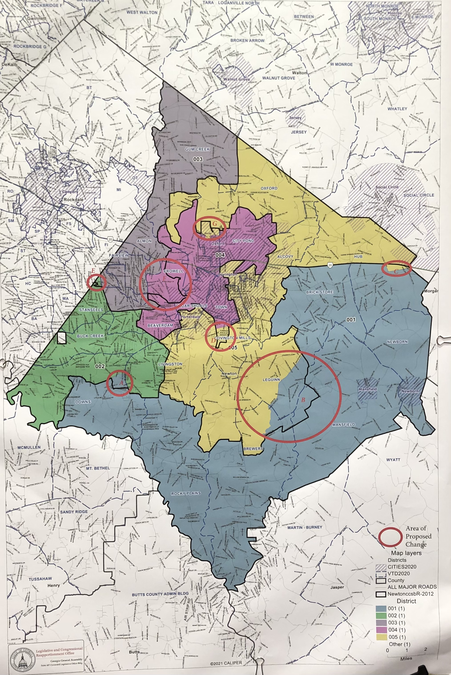
The recommended changes were divided into seven circled areas on the map members saw. They included:
• Area A: Districts 1 and 2— an area along Bethany Road near Georgia Hwy. 81 moves from District 2 to 1. Affected subdivisions are Glen Echo and Laurel Ridge, and affected roads are Carlisle Court, Glen Echo Drive, Laurel Way, Lilac Lane, and Willow Shoals Drive.
• Area B: Districts 1 and 5 — District 1 moves northward into District 5 to Dixie Road, spanning from the west of Henderson Mill Road, and then easterly across County Hwy. 213 to Elks Club and Poplar Hill roads.
Subdivisions affected are Benton Dairy Estates, Long Branch Meadows, Reserve at Bear Creek, Bear Creek Preserve, Cambridge, and Five Oaks. Affected roads are Avalon, Belcher, Benton, Benton Dairy, Macedonia and Morgan roads; Bear Creek Walk; Cambridge, Five Oaks, Reserve and River View drives; Chimney Ridge and County Meadow lanes; Old Pond Place; Preserve Trail; and Walnut Ridge Court and Way.
• Area C: Districts 1 and 5 — a small area of District 1 moves to District 5 south of I-20, east of Social Circle Road. The state recommends this change due to a “voter anonymity” issue involved with city of Social Circle and Walton County, and moving this area back across I-20 would likely cause additional issues.
• Area D: Districts 4 and 5 — a portion of District 4 moves to District 5 along Flat Shoals Road near Covington Bypass. Subdivisions affected include Hidden Pines, Indian Creek, and Magnolia Park. Streets are Ella Drive, Flat Shoals Road, Fleeta Drive, Hidden Pines Drive, Mountain View Circle, Navajo Trail, Sara Drive, Stacia Drive, and Valley Court.
• Area E: Districts 2 and 3 — a small area west of Salem Road along the Rockdale County line moves from District 3 to District 2. Salem Village subdivision is affected by this proposed change and streets including Chester Circle, Colony Drive, Hampton Trail, Ivy Circle, Ivy Drive, Old Concord Drive, Old Salem Road, Pinewood Drive, and Village Drive.
• Area F: Districts 3 and 4 — District 4 is proposed to expand westward into District 3 to Jack Neely Road and will take in Newton High School. Affected subdivisions are Brookstone, Oakwood Manor, and Newton Woods and streets including Arbor Lake Drive, Brookstone Court, Hillside Oak Lane, Lakeview Crossing Drive, Oak Manor Drive, Oak Terrace Drive, Oakwood Drive, Silver Willow Court, and Silver Willow Walk. Portions of Access Road, Brown Bridge Road, Harold Dobbs Road, and Kirkland Road are also in this proposed area of change.
• Area G: Districts 4 and 5 — A small area in city of Oxford moves from District 4 to 5, and the affected roads are Richardson Road, West Richardson Street, and Stagecoach Road (portions of Hull St. are closed in Area G map).